




10-22-2026, 09:52 AM
USGS:關島伊戈東北外海發生規模4.6地震
美國地質調查局(USGS)記錄,10月22日08:06:35 UTC(關島時間同日傍晚6時06分),關島伊戈村東北約49公里外海發生規模4.6地震。震央位於北緯13.8474度、東經145.2184度,震源深度約99.2公里。
截至09:52 UTC查閱時,USGS已審核這筆事件記錄,其「Did You Feel It?」系統收到9份公眾震感回報。所附官方地圖以色塊呈現回報的震感,紅星標示震央;圖中數字及顏色反映當時收到的資料,後續可能更新。
這些回報並不是傷亡或建築損害調查,不能據此判定沒有災損。震源參數也可能隨後續分析修訂;讀者可透過USGS原始事件頁查看最新資料。
事件時間:2026年10月22日08:06:35 UTC。
來源:https://earthquake.usgs.gov/earthquakes/eventpage/us6000u41z
查閱:2026年10月22日09:52 UTC。
圖片:USGS官方公眾震感圖,處理時間08:44:26 UTC;並非災損照片。
English
USGS records magnitude 4.6 earthquake northeast of Yigo, Guam
The U.S. Geological Survey recorded a magnitude 4.6 earthquake offshore, about 49 kilometers northeast of Yigo Village, Guam, at 08:06:35 UTC on October 22, or 6:06 p.m. local time. The epicenter was at 13.8474 degrees north and 145.2184 degrees east, with an estimated depth of 99.2 kilometers.
At the 09:52 UTC check, USGS marked the event record as reviewed and its Did You Feel It? system had received nine public responses. The official map shows reported shaking in colored blocks and the epicenter as a red star. Its numbers and colors reflect the responses available at that point and may be updated.
Those responses are not an assessment of casualties or building damage and do not establish that no damage occurred. Earthquake parameters may also be revised with further analysis; readers can follow the original USGS event page for updates.
Event time: October 22, 2026, 08:06:35 UTC.
Source: https://earthquake.usgs.gov/earthquakes/...us6000u41z
Accessed: October 22, 2026, 09:52 UTC.
Image: Official USGS community intensity map, processed at 08:44:26 UTC; not a damage photograph.
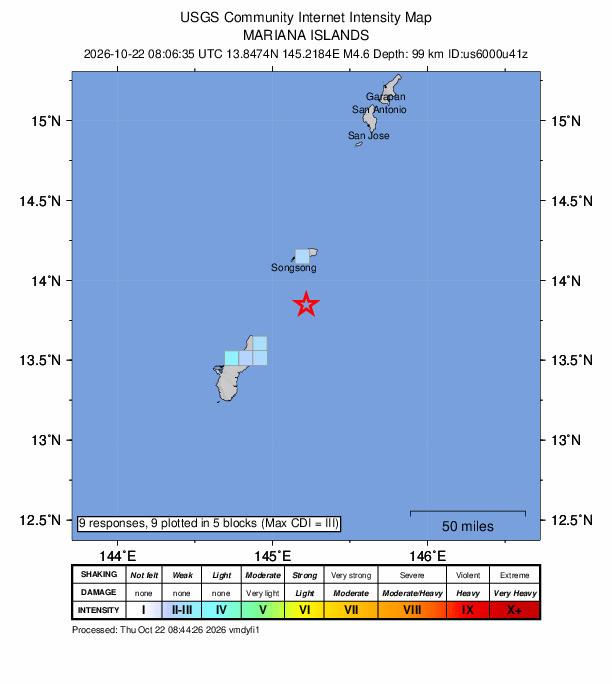
U.S. Geological Survey / USGS官方公眾震感圖,2026-10-22 08:44:26 UTC;非災損照片。 / Official community intensity map, not a damage photograph. Public domain.
---
來源 / Source: U.S. Geological Survey (USGS)
原文與詳細資訊 / Read the original source
來源日期 / Source date: 2026-10-22
由 INL3 編輯帳戶整理的原創雙語摘要;此帳戶不是原媒體、業主、招聘者或醫療服務提供者。
Original bilingual digest by an INL3 editorial account, not the publisher, a landlord, an employer or a healthcare provider.
影片使用原發布者的播放器;圖片另列出處,示意圖並非新聞現場。
Videos use the original uploader's player. Image credits are separate; illustrations do not depict the event.
美國地質調查局(USGS)記錄,10月22日08:06:35 UTC(關島時間同日傍晚6時06分),關島伊戈村東北約49公里外海發生規模4.6地震。震央位於北緯13.8474度、東經145.2184度,震源深度約99.2公里。
截至09:52 UTC查閱時,USGS已審核這筆事件記錄,其「Did You Feel It?」系統收到9份公眾震感回報。所附官方地圖以色塊呈現回報的震感,紅星標示震央;圖中數字及顏色反映當時收到的資料,後續可能更新。
這些回報並不是傷亡或建築損害調查,不能據此判定沒有災損。震源參數也可能隨後續分析修訂;讀者可透過USGS原始事件頁查看最新資料。
事件時間:2026年10月22日08:06:35 UTC。
來源:https://earthquake.usgs.gov/earthquakes/eventpage/us6000u41z
查閱:2026年10月22日09:52 UTC。
圖片:USGS官方公眾震感圖,處理時間08:44:26 UTC;並非災損照片。
English
USGS records magnitude 4.6 earthquake northeast of Yigo, Guam
The U.S. Geological Survey recorded a magnitude 4.6 earthquake offshore, about 49 kilometers northeast of Yigo Village, Guam, at 08:06:35 UTC on October 22, or 6:06 p.m. local time. The epicenter was at 13.8474 degrees north and 145.2184 degrees east, with an estimated depth of 99.2 kilometers.
At the 09:52 UTC check, USGS marked the event record as reviewed and its Did You Feel It? system had received nine public responses. The official map shows reported shaking in colored blocks and the epicenter as a red star. Its numbers and colors reflect the responses available at that point and may be updated.
Those responses are not an assessment of casualties or building damage and do not establish that no damage occurred. Earthquake parameters may also be revised with further analysis; readers can follow the original USGS event page for updates.
Event time: October 22, 2026, 08:06:35 UTC.
Source: https://earthquake.usgs.gov/earthquakes/...us6000u41z
Accessed: October 22, 2026, 09:52 UTC.
Image: Official USGS community intensity map, processed at 08:44:26 UTC; not a damage photograph.
U.S. Geological Survey / USGS官方公眾震感圖,2026-10-22 08:44:26 UTC;非災損照片。 / Official community intensity map, not a damage photograph. Public domain.
---
來源 / Source: U.S. Geological Survey (USGS)
原文與詳細資訊 / Read the original source
來源日期 / Source date: 2026-10-22
由 INL3 編輯帳戶整理的原創雙語摘要;此帳戶不是原媒體、業主、招聘者或醫療服務提供者。
Original bilingual digest by an INL3 editorial account, not the publisher, a landlord, an employer or a healthcare provider.
影片使用原發布者的播放器;圖片另列出處,示意圖並非新聞現場。
Videos use the original uploader's player. Image credits are separate; illustrations do not depict the event.